
Adapting the ‘Superblock’ and the ’15-minute city’ models to Aotearoa: density, proximity and … parking.
The “15-minute city ” is in a nutshell, built on the idea of proximity to activities and services. Cities could be designed or redesigned so that within the distance of a 15-minute walk (or bike ride), people could live the essence of what constitutes the urban experience: access to work, housing, food, health, education, culture and leisure.
“There are two essential components to city-making, public space and density. Place-making principles are based on a critical mass of population, services, organizations, associations and activities all sharing common interests in a particular area of public space.
An essential part of city-making is managing these conflict of interests amongst public space users.”
Salvador Rueda from Urbanhub Barcelona in his public talk about Ecosystemic Urbanism “Let’s Get Aotearoa Moving” last month.
Barcelona superblocks have proven a 5-minute urban experience. ‘Barcelonins’ are able to carry 6 simultaneous daily activities within 300 metres from home.
I will explain how adopting either of these two sustainable city models could be the solution to climate change and bio-diversity emergencies. The Superblock and the 15-minute city models effectively share principles.
Parking policies are designed to control on and off-street parking. They cover mobility, shared motorist, loading zones, taxi stands and short-stay parking, parking for residents, buses, coaches and motorcycles, on-street electric vehicle charging stations and ultimately on-street parking for bicycles and micro-mobility users (e.g. e-scooters).
Updating a parking policy could be a very tricky task especially when it involves local businesses expecting to park “right outside” their premises and what people are just “used to”.
As a starting point, one might think policy reviews will be effective when aligning objectives and principles with global climate and bio-diversity emergencies.
The ‘public space use’ hierarchy should dictate the parking hierarchy.
A snapshot of what public space use priorities should be:

Source: @dublincycling
What is the relationship between parking policies, density and proximity?
In order to help visually with the answer, Urbanhub Aotearoa has devised two different city scenarios.
Our hypothetical scenarios below could help in envisioning a near future where motorists are not sole protagonists and active modes are given priority.
I am using proximity as a reason to densify our centres.
CENTRAL CITY SCENARIO
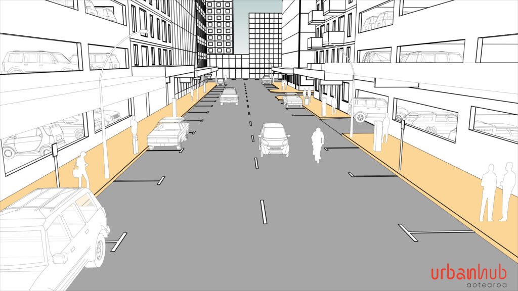
EXISTING
Let’s take a look at a typical kiwi Central Business District (CBD) double lane one-way street with parallel parking on both sides. In this generic central city scenario, motorists are using most of the street space.
Building uses are a mix of office, car parking and (some) residential.
On weekends and weekday evenings these areas have less activity so there is little conflict of interest amongst users of the space.

STAGE 1
If we remove car parking on one side of the street and introduce a utility strip (as an extension of the footpath) with native trees and spill out spaces for existing businesses and public seating areas, we have provided new ways of using this space.
People are staying for longer favouring social interactions. You might even get to socialise with your neighbour while enjoying the sunshine.
We start to see some changes in property use. Some existing buildings are already being converted from offices and car parking into residential apartments.
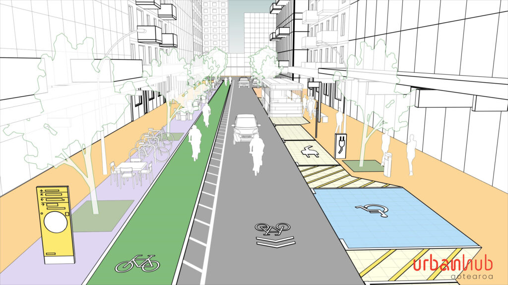
STAGE 2
Now let’s imagine that we remove one travel lane and the speed is reduced to 20 km per hour. The number of on-street parking for private motorists has also been reduced however proximity to activities and services has improved and new businesses pop up. We have turned a car priority space into an “active mode” priority space (with ground markings in the travel lane) and a protected cycle lane that runs in the opposite direction. In addition, we have provided way finders for pedestrians, bicycle stands, mobility parking, electric car charging stations, PT (bus) stops and public seating. Finally, we have eliminated the curb lines to better comply with universal accessibility standards.
“I can finally commute on my bike feeling safe and I am also proud of being able to reduce my carbon footprint”
says a local office worker
The area is booming with new businesses and people start moving into more new residential apartments. We have reused the existing urban fabric and recycled the public space for new active and passive uses. People start feeling a sense of belonging to a community.
This could be an inner street of a superblock in any of our city centres. I note Public Transport would not be recommended in that case as the superblock inner streets have a 10km/h speed limit. If you are not familiar with the superblock concept here is a quick explanation.
TOWN/NEIGHBOURHOOD CENTRE SCENARIO
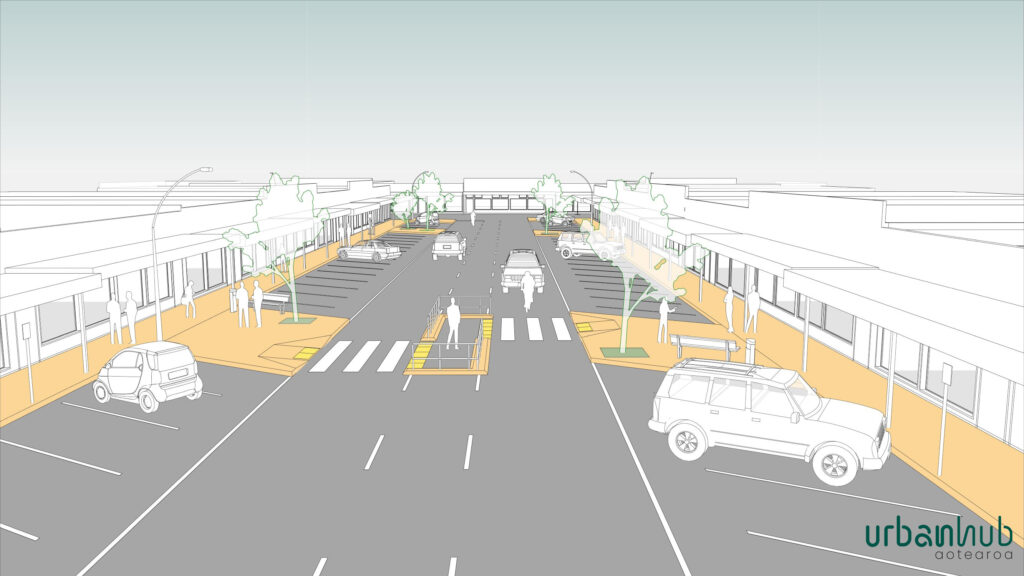
EXISTING
The illustration depicts the typical kiwi main street of a neighbourhood centre with a very wide roadbed, angled parking and some street trees on both sides.
“We had to ask Council for a pedestrian safety island after numerous complaints and conflicts between motorist and other vulnerable users.”
says the representative of the Business Improvement District

STAGE 1
We could start by providing a more legible pedestrian crossing and removing the safety island. When changing the car park on one side of the street road from angle to parallel there’s enough space to place a utility strip (as an extension of the footpath) with native street trees. This simple transformation leads to opportunities for social interaction. Hospitality businesses have spill-out spaces with tables and chairs for outdoor sitting in warm weather.
We start to see a degree of mixed-use development in the area. Small retail businesses see the opportunity and start thinking about adding residential units to their buildings; intensification begins.
At first I was not sure about developing my cornershop but now the land value has increased and with the new provisions included in the NPS-UD and the Spatial plan I could add 10 new units to my property without having to worry about car parking.
Says a local business owner
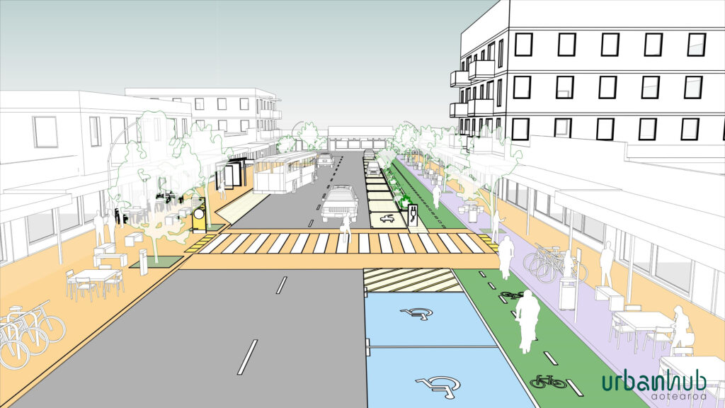
STAGE 2
The maximum speed is reduced to 20 km/h. A two-way protected cycle lane, curb extensions, transit stops and widened footpaths distribute the space more equitably while encouraging walking, cycling and public transport use.
Pedestrian raised crossings contribute to safety and way finders help improve the tourist experience and retail spending.
Intensification continues and new residential apartments rise with an increase in resident numbers and new businesses move in. We have reused the existing urban structure and recycled the public space by using inclusive principles. Social interaction has increased and the neighbourhood is more connected than ever while proximity provides for basic needs and convenience. We are building a community.
By redesigning the street to better serve the needs of all users we are a step closer to the city of proximity.
We recommend the use of tactical urbanism and co-design as the way forward for intermediate stages as it changes the public consultation experience while helping to uncover what works (and what doesn’t). Co-design delivers public benefit faster while encouraging people to work together in new ways.
Ivan Eiroa Santamarina, Urbanhub Aotearoa
Urbanhub Aotearoa can help with the conversations leading to meaningful decisions. Contact us.